Friday 29 July 2016

Day 19 Rabid Grizzly to Lava Bed BC Park July 27th


Today had a little bit of everything, highs a low and some wows and a few wrong turns. Diving down hwy 37, I pull off at Kinaska Lake BC Park, it’s still early just 8 am but I’m pulli 
ng off for a lay down break. About ½ an hour later, take a look at the lake and notice Old Man of the Forest boletes a choice find in choice condition.


Leaving there I continue down hwy 37 and I do mean down, for the last 200km it seemed that I have been going downhill all the time which can’t be right.  I pulled in for a late breakfast at the Lost Frontier Heliskiing Lodge.


Lost Frontier Heliskiing Lodge turns out to be a great place for breakfast, both for offering he best breakfast of the trip and likely for the last couple of months, but also really good value. $15 for coffee, 3 egg cheese omelet, roasted not fried hash browns, the best ever, toast and a little fruit to finish even a few of those wild strawberries.  I plug in the computer, no internet for walk-ins but I get some needed photo editing done. Turns out the guys behind me are miners talking shop. Even though there is no skiing in the summer the lodge is ½ full with mine bosses, they provide helicopter transport to remote mine sites and full service lodging.


Continuing to head south on 37, I see the first of many black bears running across the road.  Arriving at Meziadin Junction I pull off for fuel $1.225 and notice that my rear right tire is low and getting lower fast, I pull  away from the pumps and its flat within 20 yards. Fixing the very bold tire takes about an hour, I look at the other side and it too needs to be replaced very soon, driving without a spare tire for a while does not feel good.  


I return to the hwy thinking I’m on 37 but it has become 37A, which turns out to be a 62km wrong turn.  37A to Stewart is a fantastic drive; the road descends into a meadow and I get a real whiff of pine forest scent, the trees get bigger and you see a real lushness to the forest. Before long I see glaciers peeking over the mountains (Ludec Glacier) on both sides of the hwy. There is one glacier that comes all the way down the mountain to a glacier fed river. Several large waterfalls feed the river giving it that light aqua colour, the road narrows and it descends deeper into a gorge.  A few twists and turns things level out and the valley widens, I’m getting nearer to Stewart, a forest town, in the business of cutting down old growth forest in the area and by the road side, also provides Heli fly overs to the glacier.  


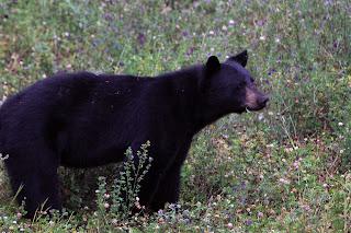
Just past the gorge area of 37A I get a really great picture of another bear, eating orange coloured raspberries.  This time I’m out of the car and looking down to the bear from behind a barrier of a bridge. Driving back you see things you did not see before, more glaciers and more waterfalls.


Returning to hwy 37, it is not long before I see the 3rd bear also crossing, than another and the sixth bear is at the side of the road.  I switch lenses and back the car up, it starts to walk up hill towards the forest and then turns around facing me sits down and starts to scratch a perfect pose


I intended to take Wheel Drive a 60km dirt road to Ness Camp but missed the turn only realizing my mistake at Kitwange some 78km past; to make up, I turn onto 46 West passing through Seven Sisters Peaks and start to see several fishermen along the river, I guess the salmon are starting to arrive. 

 Pulling into Terrace, I look at the municipal camp ground. I located on an island within the river. There is a big sign saying “bear in the park”, it’s very busy cost $26 with 1 bundle of wood, I decide to move on. Driving north on hwy 113 I look at Rosswood I pass municipal camp ground, but stop to take pics of abandoned buildings and then decide to go back and look at the camp. $5 includes wood, however they have had a forest fire and so the camp ground is among the dead trees.


Returning to hwy 113 I see what would have been the best bear picture ever, right where was standing taking old building pictures and mother bear and two cubs walk across the road. So while I’m taking pictures walking through the high grasses unbeknownst to me there is a mother bear with two cubs likely very close by, bring to bears seen today to 10.


Highway 113 goes though Nisaga’a Memorial Lava Bed Park and I pull into the camp ground. $16, no wood around but I have some. Very small camp just 16 sites but each site is very big and at least 10 years apart.  


Day 18 Tuesday July 26th Whitehorse to Rabid Grizly BC.


During the first of this trip I have felt that my car was not producing the boost is should be, there seem to some resistance in 21-2600 rpm area, while have the oil change I was inform that I failed to put the O-ring on the end of the filter stick. Today driving the car the boost resistance was gone, my old car was back, a small thing with a big impact of engine performance. 


All along the way, there are car park with warning flags, I suspect berry picking.  At all the visitor centres and even on the radio, berry picking is talked about as one the most important pastimes of the year.  I decide to pullover and have a look, wild strawberries, very little ones, no more than a centimeter; it would take a long time to pick enough for a pie.  Here too Bitter or Slip-jack boletes edible but not good, they need to be peeled and dried in the oven, in the end you can still get an unhappy stomach.  
 
Stopping next at Morley River, a point where two rivers meet.  Here too strawberries, I take pic of flowers and watch as a fish leaps for a fly. Shortly afterward I see the first dead forest from beetle.  All the free firewood at Yukon camp grounds was beetle killed pine trees.


Turning onto highway 37 south, you feel that this is back way into BC, narrow winding hilly road with good pavement but no center line. After 15km’s I reach forest fire one that last the next 30 km’s. I pull over to look at a pond within the fire zone and see that it’s a kettle pond, small and very deep, the side of the pond drop off right away.  Kettle ponds are formed by chunks of ice the brake off a receding glacier.


Last night I noticed that the sun went down in Whitehorse, late but it was actually dark at 1am, heading south now I can expect earlier nights.  I pull off and look at rest area map at Rabbit Grizzly and about 200m further down the road is a nice flat site with fire pit, lake view and table, I pull in for the night, later while walking to the lake for water to kill the fire I notice there is an outhouse which check to find its fully stocked, perfect and free. 


Drove just 628km today.

Tuesday 26 July 2016

Day 17 Monday July 25th Back to Whitehorse


The Alaskan highway again follows a river and in Canada a range of the Kluane Mountains, which is a wildlife sanctuary.  Behind the first range you can see glimpses of a very large glacier.  This part of the range is a National Park in Canada and the USA; accessible only by plane. 

Taking the turn at Haines junction towards Whitehorse, today will be an administrative day, call home, up-date the blog, get an oil change (using my oil and filter still cost $71), get a hotel. Tomorrow, a very late start, stay in hotel as long as possible. I get onto Hotwire.ca a book at the Best Western $163 ($141 + Tax) seems high but this is the north and they have a very short season, also the guy next to me as a walk in books at $180 plus tax, so again Hotwire is a good thing.  No pics today.

367km today.

Day 16, Return to Achorage and Yukon


Waking up just after 7am I continue my return to Anchorage.  I pass the fire zone and still the pull offs are blocked.  This time it low tide and the Turnagain Arm which is an inlet off Cook Inlet is almost dry.  The tides are high in the north, Cook Inlet claims to be the highest in North America, however I seem to remember the Bay of Fundy is the highest. 

Being Sunday, there does not seem much to do, I check out the artist/craft sale downtown and realize I’m not really into crafts, much of the art seems to have the made in China look to it and then it starts to spit again.  I had planned to meet up with someone from TDIClub but it’s too early to call and the library is closed for another 2 hours if open at all.  I turn of the radio and hear that rain is expected for the next week and if you want sunshine and warmth you need to go to Canada and so I decide to cut my Alaska trip short and head for the Yukon.

Spitting becomes heavy rain within an hour of driving.  However by 2pm I feel I have made the right decision as the rain stops, fog lifts and there seems to swatches of blue sky around. The first part of Glenn highway passes along a very long glacier, not seen by me due to the fog, but every now than I saw a glimpse. The road to Canada follows a series for valleys and rivers; no gold panning is this area, some logging and farming here and there. 

Canada customs fine again, I’m told that through social media someone had called the RCMP to inquiry on my safety because I did not post for several days. This is an event that I never considered of having a travel blog, I think that an added security notion when doing a long solo trip, Thank you.


 Pulling off at Lake Creek Territorial Camp ground $12, around 7pm, having driven 1012km.